Documentary Photography

Fifteen years since 9-11, a brief remembrance

It is hard to believe 15 years has passed since the most important recent historic event in my country took place on the beautiful September day in 2001. I remember everything about it. I watched the replays on the TV and yelled, waking my housemate. I remember our nation’s ability to come together in the days and hours after this attacked, as demonstrated in my home of Seattle, where thousands gathered to express sorrow, unity, and hope. I grew concerned seeing how laws were passed by Congress that were never even read by some members, notably the Patriot Act, all in the name of national security. And then there were the two wars, and conflicts still rage in Afghanistan and Iraq.

The Seattle Sikh community gathered days after 9-11 at the Seattle Center to express both their loyalty and concern in the aftermath of the attacks.

The Seattle Sikh community gathered days after 9-11 at the Seattle Center to express both their loyalty and concern in the aftermath of the attacks.

Yes, the day completely changed history, in the United States and more dramatically in the Middle East, especially for millions of innocent Iraqi civilians.

I dug these pictures out of my archive. I visited New York City in April 2005, to see Ground Zero and to see the scope of what happened. Work had already begun to build One World Trade Center. It was a silent place amid the bustle of the Big Apple. I am so glad I went.

(Click on each photo to see a larger picture on a separate picture page.)

Crazy kaleidoscope of colors at Oaks Amusement Park

During the summer, I head down to Oaks Amusement Park, the small, privately owned play land near my house. This is probably the most diverse place in all of Portland on any given Saturday and Sunday. There are families and people from every possible background here, and likely none of them very wealthy, because rich people do not visit carnie land places. It is also a lot of fun, even if you do not get on the old-school rides.

When I come down the hill to the noisy, colorful place I often bring my GoPro camera and experiment with different shots. Here is one I like. It captures the spirit of the place. You can see more photos and read more about the amusement park on my photo essay page.

Click on each photograph to see a larger picture on a separate picture page.

Historic monasteries of Egypt and challenges that face Egypt’s Copts

In 2004, I visited Egypt. This was a dream come true. There is so much history in that land, one cannot appreciate its diversity in just one visit.

My trips usually focus on projects and themes. On this trip, I wanted to explore Coptic and Christian monasteries, having recently seen and visited monasteries in the Occupied West Bank and Turkey a few years earlier. I also was influenced by William Dalrymple’s superb travel and history narrative of the monasteries and Christians of the Mideast called From the Holy Mountain.

On this trip I visited the historic Coptic Egyptian monasteries of: Bishoi and Suriani near Cairo, St. Anthony and St. Paul near the Red Sea (only made it to the entrance of St. Paul), the long-abandoned St. Simeon near Aswan, and St. Tawdros Monastery near Luxor. I also visited and stayed at St. Catherine’s Monastery, the Greek Orthodox monastery founded during the reign of the Byzantine Empire and sacred to Jews, Moslems, and Christians. Some are 1,600 years old, and all but one of those seen here is still functional today.

My host at St. Tawdros Monastery gave me a tour of the historic site, just outside of Luxor. My visit required the permission of the local security detail, who also joined me. This was one of several times Egypt's security forces went out of their way to both help me and perhaps ensure I did not do anything suspcious. This visit was one of my highlights.

My host at St. Tawdros Monastery gave me a tour of the historic site, just outside of Luxor. My visit required the permission of the chief for the local security detail, who also joined me. This was one of several times Egypt’s security forces went out of their way to both help me and perhaps ensure I did not do anything suspcious. This visit was one of my highlights.

Visiting the monastery in Luxor required official approval of the head of local security. It was a tense time at any Christian site, and across the country it got worse after my trip. There were terrorist attacks on Copts before the start of the Arab Spring, when military protection of Christian sites began to melt away. Copts, one of the world’s oldest Christian sects, faced and still face systematic discrimination by the Moslem-dominated Egyptian government. This only became worse with the fall of the Mubarak dictatorship, (Read my essay on the persecution of Copts in modern Egypt.)

Still, everything about my 2004 trip was memorable—from meeting with Coptic monks to seeing pilgrims from Africa, South Korea, and other locations file through St. Catherine’s Monastery in the Sinai, where Moses reportedly found the burning bush. While getting to each of these places proved dangerous, difficult, and expensive, I was rewarded by having a deeper appreciation of Christianity’s monastic traditions that represent some of the best elements of the faith that remain very much alive today.

You can read a history of Egypt’s ancient monasteries and Christian monasticism in Egypt in Michael McClellan’s book: Monasticism in Egypt: Images and Words of the Desert Fathers. There are also some wonderful historic photographs of monastic life from the first decades of the 20th century on this  blog published by Diana Buja. You can also buy Gawdat Gabra’s Coptic Monasteries: Egypt’s Monastic Art and Architecture.

A City of Catholic Saints and Churches

Scene above: The world-famous King St. Louis IX statue on Art Hill in Forest Park, Sts. Peter and Paul Church, St. Anthony of Padua Church. Click on each picture to see a larger photo on a separate picture page.

St. Louis’ namesake comes from French King Louis IX, one of France’s few pious rulers who ruled in the 13th century and died in 1270. The city’s European origins can be traced to French traders on the Mississippi River. One, Pierre LaClede, gave the trading post its name after the revered ruler 252 years ago. That name stuck, and the city of St. Louis was born (on ground inhabited for thousands of years by Native Americans).

The city’s name also helped to attract many Catholic European immigrants, from Italians to Germans to Irish. Many of the city’s strongest and most powerful education and social institutions, from hospitals to orphanages to private schools to St. Louis University, were also founded by Catholics. The Archdiocese of St. Louis virtually runs the city’s homelessness programs and non-profit social service sector.

For a visitor to St. Louis, one of first things one sees are brilliant and beautiful church spires rising tall above old neighborhoods. These institutions still play a vital role in many depressed areas of the fading, formerly great industrial city. Every time I visit my family in neighboring University City, I always take a tour and rediscover this amazing legacy. I still am dazzled by the skill and confidence with which St. Louis’ earlier residents built their community purposefully, to live up to the city’s name.


North St. Louis, a gentrification-free zone

(Click on each photo to see a larger picture on separate picture page.)

I recently visited St. Louis, to see my family. I normally use my visits to tour historic sections of the once proud and fourth-largest U.S. city in the late 1800s. But those are the long-gone glory days.

Today, the city is struggling to define itself in the post-NAFTA, post-industrial reality of the “new economy” that has led to the greatest level of income inequality the nation has seen since before the Great Depression.

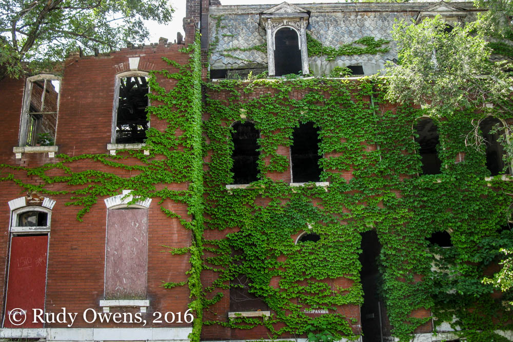
The pain and fragments of this change are visible everywhere in the city, mainly in the form of shuttered factories and feral and abandoned houses that almost give Detroit a run its money as the epicenter of U.S. urban decay. They are most pronounced on the city’s north side, historically the racially demarcated home to the city’s poorer African-American residents for more than eight decades. That is the story I went out to photograph this trip, in June 2016.

Love can be in short supply in north St. Louis.

Love can be in short supply in north St. Louis.

St. Louis experienced what many Midwest, industrial cities confronted during and after World War II. The U.S Interstate System promoted out-migration to the surrounding county. White flight rapidly accelerated population losses following the 1950s. (See a superb illustration of that white flight here: http://mappingdecline.lib.uiowa.edu/map/.) The population dropped from 880,000 residents at the start of the 1950s to a mere 315,000 souls in 2015, according to the most recent U.S. Census Bureau estimate.

Industry, including automobile manufacturing and other sectors, began a long slide to obsolescence. St. Louis and the surrounding region were once major players in automobile manufacturing and home to several “Big Three” plants: one Ford, two Chrysler, and one General Motors. The city’s world-famous Corvette plant closed its doors in 1981 after a 37-year run. At its peak it had a payroll of more than 13,000 employees. Since then, Ford shuttered its plant in nearby Hazlewood in 2006, and Chrysler closed two plants between 2008 and 2009 (north and south plants), costing the region about $15 billion, according to one study. (GM still has an assembly plant 40 miles from St. Louis in Wentzville.)

I wanted to see first hand how things look on the city’s infamous north side, or “home” as it is known to its residents. It had been years since I did such a trip. I was startled by the lack of businesses except gas stations, beauty shops, food and restaurant establishments, and garages.

I met a sixty-something man on a street just off Vandeventer Avenue and North Market Street. He told me he had worked for Chrysler until being laid off in 2009, when the Fenton plant was shuttered for good, before the factory was razed to the ground. A grandfather, he called himself T-Bone, and had just purchased his two-story brick home for $24,000. He hoped to acquire two adjacent lots through a process that allows property owners adjacent to vacated lots to acquire those lots at no cost after three years of maintenance. He told me he wanted to become more engaged in local politics to help restore his section of the city. He lived two houses down to a boarded up, abandoned home, one of several on his block.

Beautiful old brick homes have long gone feral in the economically challenged neighborhoods of north St. Louis.

Beautiful old brick homes have long gone feral in the economically challenged neighborhoods of north St. Louis.

Today, more than one in four St. Louis residents live in poverty. The U.S. census puts the median household income in the Gateway City at $35,000, well below the U.S. average of $53,000. Racially, the city is as divided as ever with blacks and whites evenly divided, and now Hispanics and Latinos numbering (officially) under 5 percent.

All of these numbers mean that the city, and its poorest residents, are struggling. That struggle can be seen on just about every block north of Delmar Avenue, all the way to the city’s borders with adjacent and also struggling municipalities like Jennings. Anyone visiting the city should soak its charms—the Gateway Arch, the amazing churches, the historic downtown, and especially charming and historic Lafayette Square.

Then they should take a drive for an hour or two and see what life in the new urban, post-industrial America looks like. Gentrification is not a problem that is displacing residents in the city’s north side. No urban, yuppie, or tattoo-covered and scrappy millennial pioneers from the affluent suburbs are rushing to create art centers or startups in old factories sites. This is the place people leave if they can.

This is not Portland, Seattle, or Boston. This is a much tougher, more violent, and grittier place. It is also in many ways a more friendly place too, where people will still say hello if you have street cred and give them respect. This is St. Louis, and the recovery, if it comes, is still a long ways off. Without long-parted industry, that future is still not certain.

Industrial architectural icons of St. Louis

St. Louis has more than its magnificent Gateway Arch to showcase the city’s rich industrial and economic past. During my recent visit, I caught a few of the city’s most iconic structures: the old Falstaff Beer plant in North St. Louis, the Union Electric Company energy plant in the city’s industrial riverfront, and the massive grain silo facility in central St. Louis, now owned by the Ray-Carroll County Grain Growers Inc. cooperative.

Click on each photo to see a larger picture on a separate picture page.

St. John’s Bridge, Icon of the Northwest

(Click on each photograph to see a larger picture on a separate picture page.)

St. John’s Bridge in Portland is one of the most recognized icons in the region. It was built using local dollars at the height of the Depression, taking two years to build. The steel suspension bridge connects the Northwest and Northeast quadrants of the city. Its towering Gothic inspired towers create a feeling of awe. When it opened, apparently elephants walked across it (if one is to believe the information posted in the park below).

It is showing real signs of decay too, with its concrete foundations crumbling in plain view. Cathedral Park at its base on the northeast side of the Willamette River is an ever popular destination for residents. Everyone always seems to marvel at the design.

The base of the bridge was once home to the region’s Native Americans, who lived on the river banks, harvesting the river’s bounty. Most of the region’s Native residents perished during the 1800s due to the apocalyptic impact of communicable disease and malaria introduced with the arrival of European and American travellers and settlers.

St. Louis, once a great city

Before the Arch was built, St. Louis aspired to greatness through the early 1900s. It then began its long spiral downward. This once prosperous industrial city has seen most of its manufacturing leave and the population contract since the 1960s. Suburbanization, car-centered urban planning, racism, and very painful economic restructuring completely changed this community. The city’s leadership and the corporate owners of the St. Louis Cardinals still managed to build a new baseball stadium for the beloved Redbirds downtown. I still love this city, despite having completely opposite feelings growing up there.

You can track the demographic changes in St. Louis, St. Louis County, and the surrounding bi-state area on this very informative interactive map. You can also read how eminent domain and the freeway system destroyed neighborhoods and fragmented the city. The Arch, that great structure I love so dearly, was part of this process that leveled entire blocks.

Click on each photo to see a larger picture on a separate picture page.

Forgotten graves at the Chemawa Cemetery

Just east of Interstate 5, as one approaches the city of Keizer, Oregon, from the north, sits a mostly forgotten burial ground. I never knew of its existence until I looked at a Google map, planning a trip to the Salem, Oregon, area last fall. I was unaware that the Chemawa Indian School and its adjacent cemetery called Keizer home.  According to the school’s web site, the facility dates to the 1870s when the U.S. Government authorized a school for Indian children in the Northwest–a practice that removed children from their culture and families.

Native American girls at Chemawa work in school training programs for “home economics” skills, in this image dating from 1886. (Image courtesy of The West Shore and found at: Offbeat Oregon: http://offbeatoregon.com/1212d-chemawa-boarding-school-cultural-treasure.html

Native American girls at Chemawa work in school training programs for “home economics” skills, in this image dating from 1886. (Image courtesy of The West Shore and found at: Offbeat Oregon: http://offbeatoregon.com/1212d-chemawa-boarding-school-cultural-treasure.html.)

This was a period of highly criticized forced cultural assimilation of the region’s and nation’s Native American population into general society through education. The boarding high school just outside of Salem was first built in 1885, following an earlier one outside of Portland. The school claims it is the “oldest, continuously operated boarding school for Native American students in the United States.” It continues today, and is off limits to outsiders without permission to visit. The campus has Native American art, a sports field, and sits near the cemetery. Here children who were boarded at the school and who died while in the school’s care are buried.

So, naturally, I wanted to take a closer look given the boarding school would not let me see the campus grounds. The cemetery is in earshot of the freeway roar, and has pines standing on it, surrounded by a steel fence. The graves are modest, bearing names of youth who died from the early 1900s toward the mid-20th century.

I was struck by the number of deaths, as marked on tiny concrete grave markers, which listed 1918 as the year of death. That year the great pandemic spread worldwide and claimed more than 21 million lives–more lives than the battlefields took during the Great War.

A few months after my visit, the Al Jazeera news organization in January 2016 reported a Native American researcher, Marsha Small, had concluded that there were more than 200 documented graves at the Chemawa Cemetery. According to the somewhat critical story, “Government records indicate that epidemics of tuberculosis, trachoma and influenza often swept through overcrowded dormitories at the boarding schools, where children were often malnourished and exposed to germ-infested conditions due to inadequate funding.”

The pandemic that was sweeping Oregon was so severe in 1918 and 1919, that Oregon lawmakers cancelled their legislative session out of fear of the killer flu virus. The Oregon Quarterly reports that the first cases in Oregon were reported on the University of Oregon campus in October 1918. Given the conditions of a boarding school, it is likely it could have taken hold at Chemawa too. The cluster of three deaths over a four-day period is almost certainly an indication of a contagious disease, such as influenza. However, no additional information is listed on the headstones of these long forgotten young people, who died far from their families, in a place most people still do not know exists.

In an instant, everything can change

You truly never know how tested you are until everything changes, and your world flips, and what you thought to be true one moment is no longer true the next. It is at those times when you make your hardest choices and decide what matters most. I took these pictures in the Methow Valley in August 2014, when the world changed for some. (Click on each photograph to see a larger picture on a separate picture page.)