(Click on each photo to see a larger picture on a separate page.)
There is an entire genre of photography devoted to the collapse of the United States’ consumerist structures, notably the shopping mall.
Malls in decay represent a specific type of schadenfreude in a country where consumer activity drives about 70 percent of our economy. The collapse of the venerable shopping mall, a landmark from the 1950s through the 1980s, in mostly suburban American, reveals deeper troubles in our economy and the promises we were told and believed.
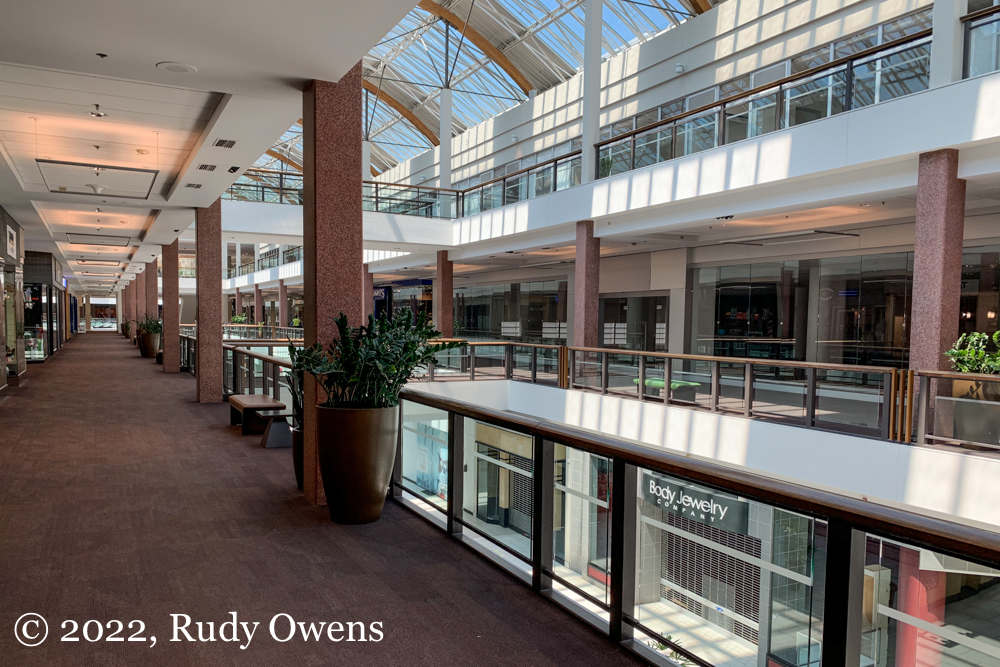
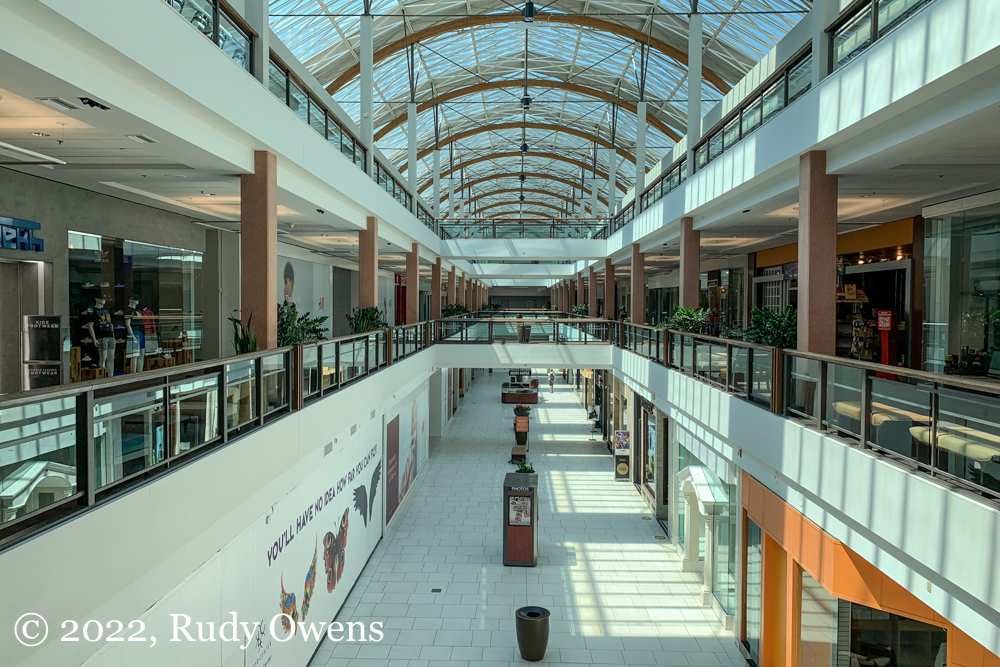
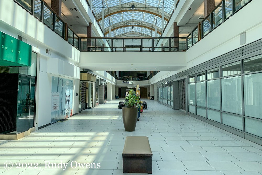
The Lloyd Center, a major landmark in the Lloyd District in Portland, has been slowly dying for years. There were efforts to revive it as late as 2021, and it’s all but certain as of late July 2022 the final nail in the coffin appears to have been pounded in.
I made what might be my last visit to the Lloyd center in late July 2022, when I was working at the state office building nearby, on the hottest day of the year. The center was meant to be open as a cooling center. The ice rink was still being used, even as the thermometer outside was pushing 95F. Nearly all the stores were shuttered, and major retailers had closed their doors.
I for one will miss it because it provided an urban retail space to serve many residents who didn’t have cars and who didn’t want to drive to the suburbs. I imagine there are other photographers like me getting their final photographs before the death of yet another American shopping mall is formally announced.
(Click on each photo to see a larger picture on a separate picture page.)
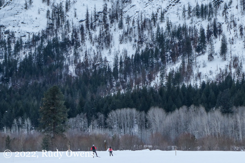
I became a passionate cross-country skier mostly because I had the good fortune of living in Anchorage from 2004 through 2010. There I was blessed with a fabulous and publicly-owned set of multi-use trails and trail systems in parks. I could ski sometimes nearly six months a year, depending on when the first snows came and when the last snows melted.
I mostly remember skiing being very accessible to nearly everyone because the trails were close to home and because gear was not too expensive for the basic set up of boots, poles, bindings, and skis. You could even get used equipment.
The local group promoting the sport and maintaining the trails, the non-profit Nordic Skiing Association of Anchorage, was committed to youth inclusion for all residents. That meant all young people, regardless of race.
When I lived there, Anchorage was more diverse than many outside of Alaska think, with about 65 percent of the residents who identified as white and 35 percent being non-whites, with the largest group being Alaska Natives. Some of that diversity could be seen in the faces of the young skiers competing for the high school teams and on the trails. But even then, in this very democratic and outdoor-oriented place, the faces I saw skiing were like me—white.
However, cross-country skiing in Anchorage is not like cross-country skiing in the rest of the United States. Today the almost entire lack of diversity of this sport nationally remains cross-country skiing’s great Achilles’ heel. That reality is not addressed with the type of debate that is needed.
In my view, everyone who does this sport, either Nordic or single-track style, knows this racial breakdown whenever they ski. If they do not, they are willfully fooling themselves from the facts before their eyes every time they clip into their skis and head out on trails in recreation areas that remain almost exclusively the domain of white Americans.
Race and country-skiing are mostly taboo topics in the multimedia world dedicated to the sport and those who do it. However I found one recent article on the racial divide in this sport I still love on the FasterSkier website. Refreshingly, it confronted the basic facts about the folks who do the sport and the factors contributing to its glaring and overwhelming whiteness.
In the United States, cross-country skiing remains an outdoor activity mostly pursued by whites, including the many winter recreational visitors to the Methow Valley (like the author).
Skier and writer Ben Theyerl wrote in an article published in August 2020: “The demographics of where the places that harbor Nordic ski communities are on a map allows this statistic to go unchecked. The trail networks linked to small rural towns and resorts that are historically, and presently, white, shelter us from having to confront and come to terms with our sport’s lack of racial diversity. So do the images of our heritage as a Nordic community, and of what it looks like to be an elite Nordic athlete. … We can choose as a community to stay on this sheltered path, or we can take the road less travelled for the Nordic community to finally discuss the overwhelming whiteness of our sport and the places that we do it in.”
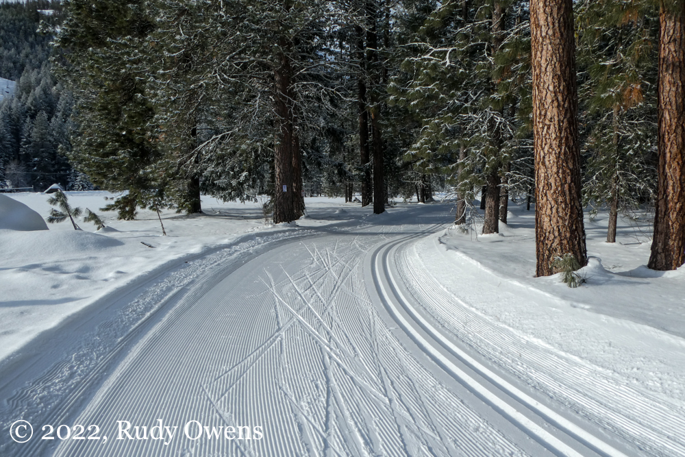
Cross-Country skiing in Washington and the Methow Valley
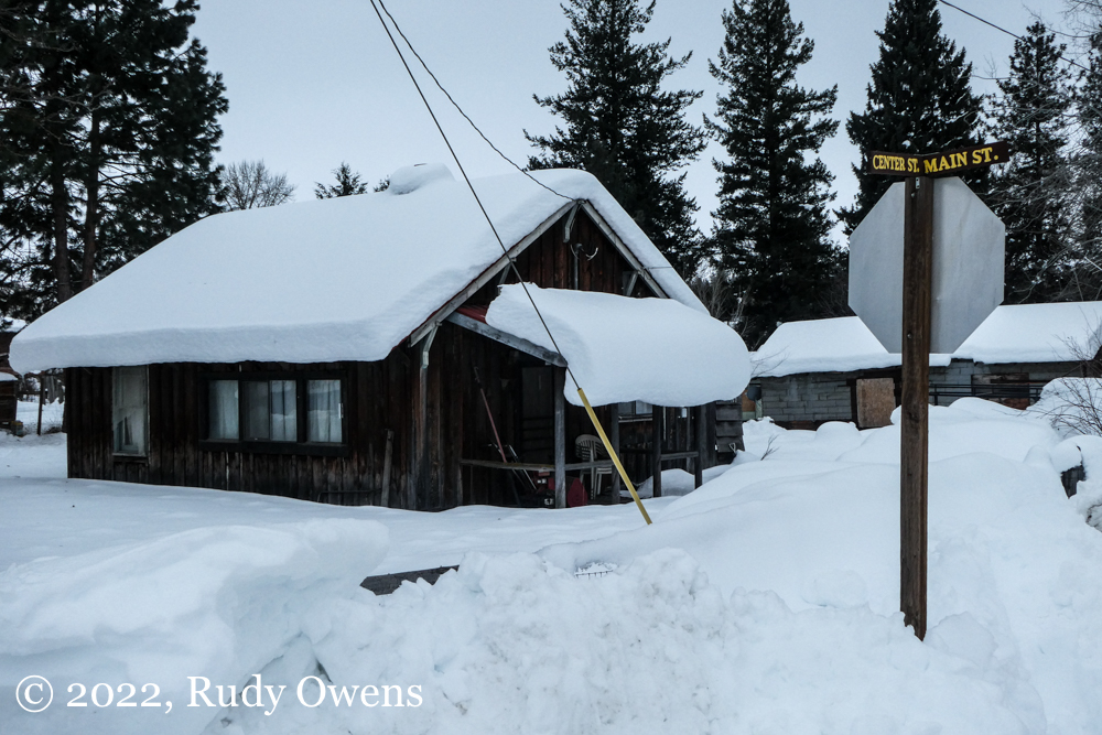
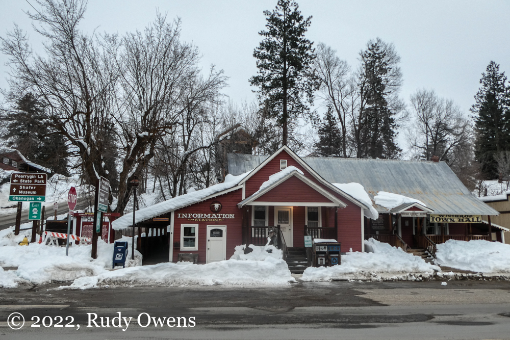
Downtown Winthrop has kept its old West look and feel, even as the surrounding area has become a magnet for wealthy residents of Washington state who have purchased their winter and summer recreation homes here.
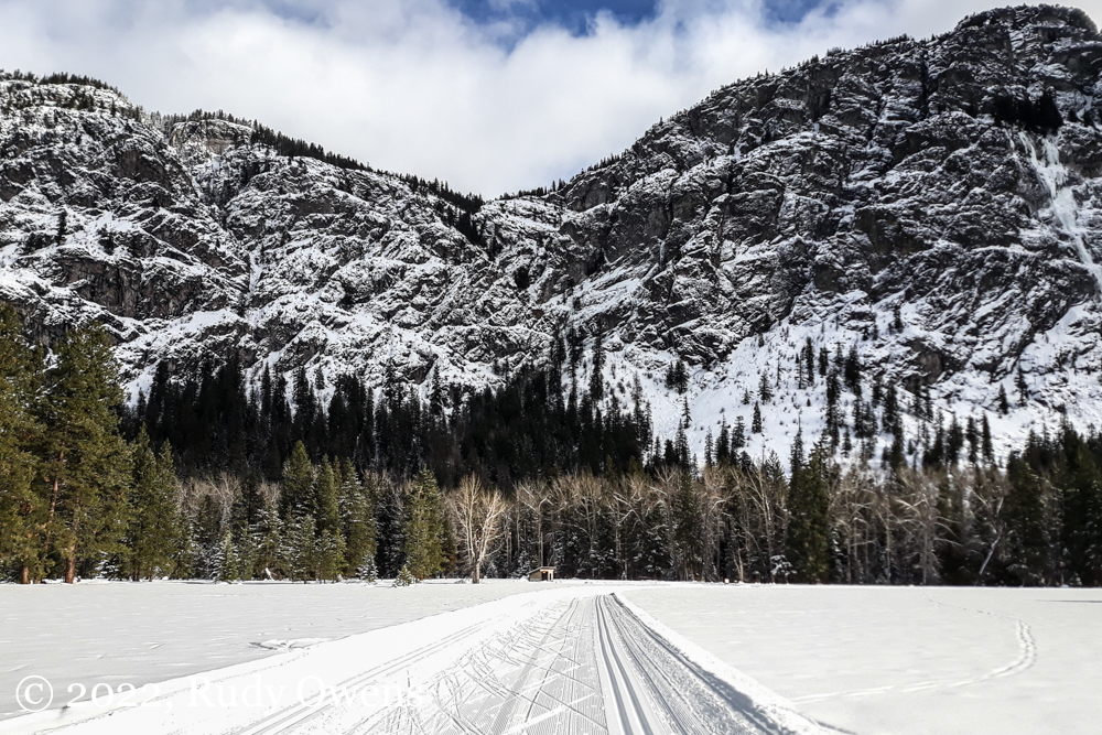
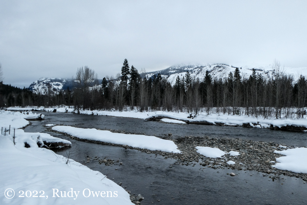
As a former resident of Washington state in the late 1980s and early 1990s, and then again through 2004, and finally 2010 to 2014, I have cross country skied there during the winters of my now former state. My adventures over these years took me at different times to the scenic Methow Valley, in Okanogan County, just south of the Canadian border and west of the Cascade Mountains.
Once an area that had homesteads and ranches on former Native American lands, it is now dotted with second and third homes of the upper middle class, the wealthy, and also the extremely wealthy—many from the Seattle area.
Since my first visit in late 1987 to this past weekend, I have seen it transform into a year-round recreation area that promotes winter sports and cross-country skiing. The residents who live and have lived there famously developed a wonderful trail community during these decades. That is seen in the group called the Methow Valley Trail Association (MTVA), which is a non-profit organization that maintains the incredible network of classic and single-track trails, snowshoe trails, and now fat-tire bike trails.
According to the MTVA’s website, the volunteer-led group maintains “over 200 kilometers (that’s 120 miles) of cross-country ski trails in the winter months,” and that network “is recognized as one of the finest trail systems in North America for Nordic skiing, mountain biking, trail running and hiking.”
I would argue that the Methow Valley is, without question, one of the finest cross-country ski areas in North America thanks to its geography, plentiful and mostly predictable snowfall, and the good work of these volunteers and donors who support this form of recreation. The area, like so much of the United States, also has racial divisions that can be seen in where most of the county’s non-white residents call home.
According to the 2020 U.S. Census Bureau, Okanogan County had a population of 42,104 as of 2020. The sparsely populated and beautiful mountainous county includes the towns in the Methow Valley like Winthrop and Twisp and neighboring cities like Omak. The Census Bureau reported that the county is 64 percent white (non-Hispanic or non-Latino), followed next by Hispanic or Latino at 21 percent, and American Indian or Native Americans at 13 percent. The diversity from the two next largest groups can be found in communities closer to the Colville Reservation like Omak and towns like Pateros and Brewster, where agricultural work is plentiful and Latinos have long-settled because of farmwork-related employment opportunities like other communities in central Washington.
However, that diversity is not visible in the Methow Valley. During my recent three-day visit, I saw some visitors who I would identify as having Asian ancestry, but no one on any trail who was African American. Most of the skiers I saw on the gloriously groomed trails were white like me. It is a fact that one cannot ignore when enjoying the beauty of this great sport. This fact has not changed in the last 12 years since I began skiing there after returning to the Lower 48 from Alaska (as Alaskans refer to the lower states).
The Future in Washington’s wealthy, winter Shangri-La
As the ski community grew in the Methow Valley in the last two decades, so did the country’s income inequality gap. That gap has accelerated the concentration of wealth in the hands of an ever smaller number of richer Americans since the Great Recession, and more recently the pandemic.
That wealth concentration can be seen in patterns of land use in the Methow that are visible to any visitor who travels there. Those who can afford to purchase retirement homes and summer and winter second and third homes—mostly white and wealthy affluent out of towners—have chosen to settle in this area, with its spectacular vistas and abundant forms of recreation that cater almost entirely to white Americans.
Winthrop resident Solveig Torvik described this in her column from Aug. 4, 2021. “The Methow many of us so smugly assume is a model of a caring community with widespread civic engagement … reads instead much like a cautionary tale of a failed society,” she wrote. Torvik pointed to a study of the valley by a Washington State University sociology professor, Jennifer Sherman, who described the obvious divisions: “The Methow Valley is a deeply divided community where wealthy urbanites ‘blind’ to their privilege ‘hoard’ their social capital while impoverished, excluded, resentful rural old-timers struggle to survive.”
The valleys surrounding Winthrop are now dotted with high-priced, new homes that cater to wealthy residents, who are not afraid to flaunt their wealth, and the affluent who are choosing to live in what the local media The Methow Valley News calls a new Zoom town during the so-called “COVID land rush.”
According to an Oct. 7, 2020 story in the local newspaper called The Methow Valley News, a virtual “COVID land rush” is underway, fueled also by the pandemic: “One thing it means is a dramatic increase in median home prices in the Methow Valley. The median home price in September this year was $440,000, compared to $329,000 in September last year and $312,000 in 2018, based on statistics [broker Anne] Eckmann compiled from the Northwest Multiple Listing Service. In mid-September, there were 34 homes available for sale in the Methow Valley — 10 of them priced under $350,000 and eight priced over $1 million, Eckmann said.”
This is not that different than other winter resort areas in the country in Montana, Colorado, Utah, and Vermont. What’s different now is how visibly those new, rich residents have settled in the last 15 years in the Methow Valley, particularly around the town of Winthrop. I have seen that change since I first Nordic skied here in 2010 when I moved back to Seattle, and then visited a friend who lives near Winthrop. It had been eight years since I was last there in February 2014.
Battles over future comprehensive planning in the county and water rights remain active, with many newcomers seeking access to the limited water resources and groups seeking to manage and plan for future growth. Growing threats from climate change and wildfire also have further exacerbated debates over growth tied to the desires of the wealthy to live in the fire-prone wildland urban interface, in places like the Methow Valley. The battles will likely continue there, similar to conflicts in communities in the West that have confronted the old maxim that “water flowing uphill to money.”
I do not know when I will travel to the Methow Valley again. It is a 400-mile journey by car from my home in Portland.
I took this trip to take a needed break from my work on Oregon’s pandemic response. I needed a recharge, and Nordic skiing is one way I can do that. It worked, too.
I enjoyed my stay with a longtime friend who moved there years earlier, who shared with me the struggles she is seeing as a resident over development there. In the end, I am left with almost magical memories of groomed trails, snow-covered mountain peaks, and the ongoing awareness that this sport that I once did daily on a community trail in urban Anchorage is still not widely shared by many.
(Click on each photograph to see a larger picture on a separate picture page.)
Oregon, geographically and geologically, is an assemblage of parts that don’t truly make for a whole. Like its northern neighbor, Washington state, it is divided by ecosystems that also provide a rough border of the political divisions that have never seemed deeper, particularly following the dangerous four years of twice impeached former President Donald Trump.
West of the Cascade Mountain ranges are the state’s most densely populated areas, and they are more to the left in the northwest corner of the state. The lands east of the Cascades are sparsely filled. They include the northern farming counties of Gilliam, Morrow, Sherman, Wasco, Union, and Umatilla.
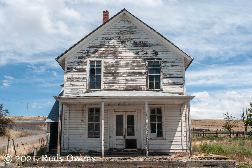
On this trip I passed through Gilliam County, which features stunningly scenic rolling hills and an endless supply of wind that led to the siting of extensive wind farms. Outside of the federally recognized tribal holdings and communities, the areas is overwhelmingly white, but is now seeing an influx of some Latino residents, who do much of the agricultural work in this part of the state. Politically, this is as red as red gets anywhere in the United States.
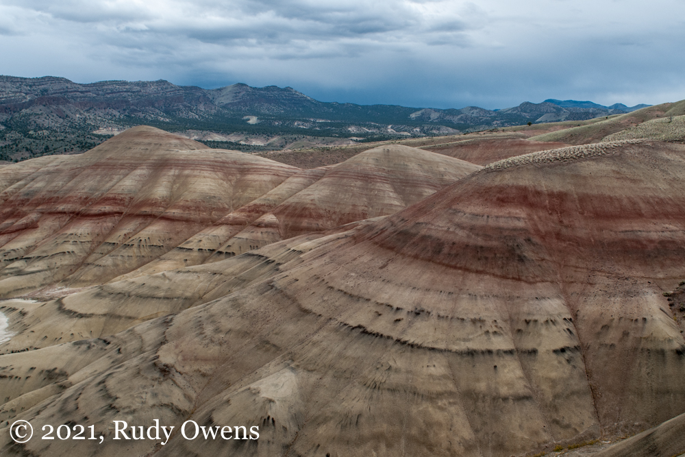
I drove south from the Columbia River Gorge on Highway 206 through Condon, then took a right going south on Highway 19 through the abandoned intersection community of Mayfield to Fossil. Here is where landscape turned from rolling hills to deep canyons, revealing millions of years of geological history. Farms that draw from the John Day River line the roads that wind through a “scenic byway.” Some of these stunning geological formations are partially protected in a federal land management area called the John Day Fossil Beds National Monument. The area has some of the richest collections of fossils spanning a 40 million year period, showing the evolution of species, plants, and ecosystems that existed long before homo erectus walked out of the plains of Africa to populate the planet.
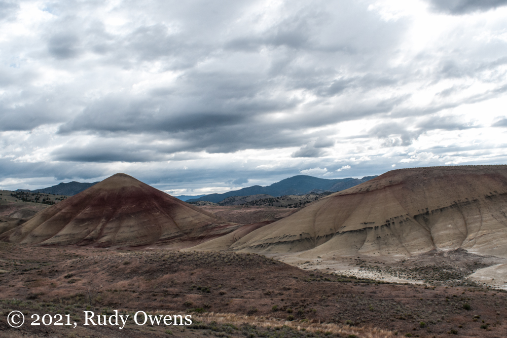
After a brief stop at the monument’s fabulous visitor’s center, I took a right and headed west on Highway 26 that took me through more stunning canyons, multimillion dollar ranch holdings of land barons, and to the turnoff for the Painted Hills Overlook, which are some of the most photographed hills in the annals of photography. I first came here in 2003 and had forgotten how stunning the scenery was.
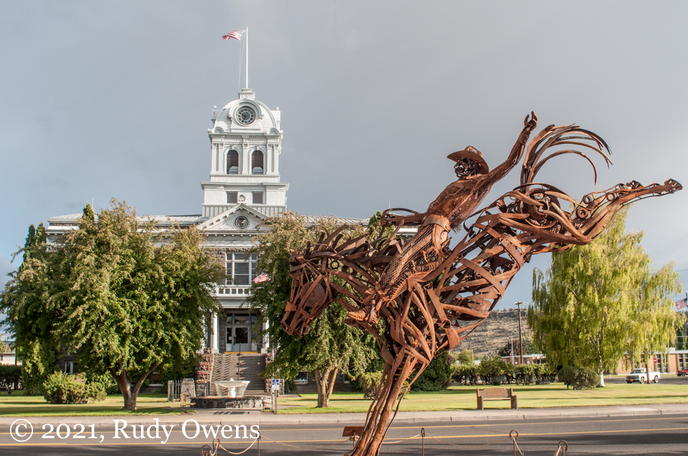
After taking a great walk and taking my obligatory tourist photos, I jumped back on Highway 26 (the Ochoco Highway), which climbed through the scenic Ochoco National Forest, where sites of recent forest fires were visible. Along the way I observed how severe the drought conditions were, with the Ochoco Reservoir down at least 20 feet. I passed through Prineville, which once identified itself as a town tied its ranching and agricultural past, celebrated in its public art. In reality, it has become a bedroom community for nearby and fast-growing Bend, about 25 miles to the southwest. The community is now home to larger data servers that tap into cut-rate cheap federal power provided by the nearby Bonneville Power Administration dams on the Columbia River.
Facebook recently announced it was building two more buildings here on top of nine existing structures, with operations the size of 80 football fields. The new investments will cost $2 billion. Apple also operates large data farms here as well. These investments make the bucking bronco and cowboy sculpture feel as old an a Roman antiquity sculpture.
Rudy Owens at Paulina Lake, smiling because it snowed the night before in early June 2021.
I ended my drive in Newberry Crater, another national monument about 45 minutes southeast of Bend. This is one of my favorite places in Oregon. It similar geologically to the much more famous Crater Lake National Park, but more developed for campers and fishermen. The day I arrived it was nearly 32 F, and it snowed during the night. I had almost an entire campground to myself. I woke up with white stuff on my tent, and it was still the second week of June. I loved that, actually! From my campground, I did a long overdue nearly 8 mile run around Paulina Lake, which is one of the finest running loops I have done anywhere. That was worth the trip alone.
(Click on each photograph to see a larger picture on a separate picture page.)
This week, the world reached a grim milestone since the first cases of COVID-19 were reported in Wuhan China in early 2020. The Johns Hopkins Coronavirus Research Center reported the global death count from the pandemic had topped 2 million, and was growing daily.
Some days I feel like I have awoken in an alternate reality, seeing mothers walking by, wearing face masks and pushing baby strollers, like I did this morning. It was jarring. I never thought I would experience this, though I always deeply sensed something like this might happen.
I felt that uneasy feeling of disconnect just after the start of the new year in Portland’s Lloyd Center district. I had come there to visit a dentist around noon.
Ordinarily, the business and retail area on the city’s east side would be filled with people, particularly on their lunch hour. Instead it was eerily silent and devoid almost entirely of the site and sound of humans.
I stopped to spin around in a circle, and realized I was alone. We had already retreated, globally, to the safety of closed spaces, eschewing contact, to avoid catching the highly contagious novel coronavirus.
I took a few shots of empty urban spaces of my cellphone, to capture that moment. Looking at the photos now, they look and feel disquieting, just like the scene outside my window of the mother and children, masked out of fear and caution.
(Click on each photograph to see a larger picture on a separate picture page.)
During my last visit to St. Louis, I indulged myself. I decided to stay in a historic mansion that is now a a bed and breakfast called the Lehmann House, just off of Lafayette Park, in the historic Lafayette Square neighborhood of St. Louis. This beautiful section of urban space is unrivaled in any U.S. city. It was one of the earliest planned communities in the once mighty industrial city, and it catered to the very wealthy when it was developed in the 1800s. It was built around the oldest municipal park west of the Mississippi River, Lafayette Park.
I have shared photo essays on my blog before about the area’s exquisitely built brick homes and architectural styles. I did not have much time to enjoy the area as I had hoped, but I squeezed in two morning walks that were about as perfect as I can remember, ever. The light had that brilliant Midwest-morning Kodacolor glow, and the air smelled fresh from a recent rain. I wandered around the “hood” and snapped these shots, allowing my senses to guide me. If you visit St. Louis, you have to put this place on your list. You will then wonder what we have done so wrong in urban design since we built communities with craftsmanship and care not that long ago.
(Click on the image see a larger picture on a separate picture page.)
I spent eight and a half years of my professional life working for the Government of Canada, for its Department of Foreign Affairs and International Trade (now called Global Affairs Canada). I did that as a U.S. citizen, working for the Consulate General of Canada in Seattle and then for the Consulate of Canada, Anchorage. I enjoyed every minute of that experience, serving the Canadian people and helping build better relations between the peoples separated by the world’s longest and most peaceful border.
Tomorrow, on July 1, Canadians the world over and through that “blessed land” celebrate the confederation in 1867, known today as Canada Day. It’s a joyful time, and Canadians I know celebrate it traveling, with friends and family, and often in Canada’s beautiful outdoors.
To all of the Canadians I know and never met, thanks for providing me the wonderful opportunity to have visited your country, work for your country, and celebrate its values and traditions that remain a pillar of openness, democracy, and freedom the world over.
I took this photo during one of my many trips to Ottawa, when I worked for Canada. I positioned myself on Wellington Street, looking northwest on Parliament Hill to the Eternal Flame and the Parliament Building, the seat of Canada’s national government. If you ever get a chance to visit Ontario, add Ottawa it to your list. It is a beautiful city, and this building is among the finest I have ever toured.
The old National Candy Factory factory is now owned and operated by U-Haul.
The National Candy Company factory in St Louis is now operated by U-Haul.
U-Haul now operates the old National Candy Company factory complex in St. Louis.
Resurrection Catholic School
In St Louis, residents can kneel and then raise a glass, all on the same block. This is a shot of the St. Anthony of Padua Catholic Church on Meramac and Behrmann’s Tavern.
Urban Eats on Meramac
City Life, in south St. Louis
(Click on each photo to see a larger picture on a separate picture page.)
If you have not heard, snow and cold have returned to the Midwest causing all manner of havoc. I grew up in St. Louis. I remember it as a city that regularly experienced winter. Cold temperatures and snow were the norm. That is not true anymore.
I mostly left the city in the 1980s, and I have returned repeatedly since to visit family and see the good people I know there. Since that time, with global warming, winters have become milder in the mid-Mississippi Valley. Snow and winter became less predictable.
However, the austere beauty of St. Louis in the winter still excites me visually. I love the contrast of the white snow and the dark, red bricks that were used to build many of the homes, factories, and warehouses.
Here is a sampling of some winter shots from my archive. All of these were taken in south St. Louis, where the city takes on a different winter feel with cold and snow.
Fun fact: The National Candy Company factory building, shown here, is on the National Register of Historic Places and was once the largest candy factory in the United States.
(Click on the photo to see a larger picture on a separate picture page.)
Halloween is approaching. I have never been a fan of this holiday.
Perhaps I don’t like it because I feel during my life I had enough real-life scares and unsavory characters to make a holiday that makes light of horror seem absurd. Or maybe I just don’t feel the spirit to dress up and change my identity to escape from my reality. It could be that too. I have been this way most of my life, and it is OK.
With the holiday approaching, I was thinking about a real place that was my personal place of unpleasantness. That would be Huntington, West Virginia, and Chesapeake, Ohio, just across the Ohio River.
This region, on the edge Appalachia, remains trapped in intergenerational poverty. Huntington today is as impoverished as it was in the years I spent there, periodically, in the 1970s. The city today has a poverty rate of a whopping 30 percent, with median income just below $30,000 a year, according to the U.S. Census Bureau. It feels as if good times have still never come.
I came here for years after my parents divorced, spending weeks at a time. My sister and I would visit my father, who lived in Huntington and then across the river in Chesapeake. Those are not pleasant memories for me. I briefly describe them in my memoir, You Don’t Know How Lucky You Are, which I published in May this year.
All of the places captured in these pictures have a special meaning for me. They are part of my memory of unhappy times, when I had to get tougher than I thought I was, and do that much quicker than I thought I could. I came back here in 2015, in order to revisit those many swirling memories as I wrote my memoir that tracks my life through bad times and good.
So to honor this holiday, with tens of thousands if not more drunken revelers cross dressing, wearing zombie outfits, play acting as if they were cast members of fantasy shows, or perhaps becoming something fun even, I give tribute to All Saints Day on the Catholic Calendar and Día de los Muertos on the Mexican calendar. Here are some black and white shots, from 2105, reflecting on that time when I confronted those things that frightened me and likely should have beaten and broke me.
Read my book and learn how well things came out in the end. Trust me, I did well when one measures success and fulfillment in the span of one’s lifetime. You can order my book today and learn how I did it.
Pat Connolly Tavern in Dogtown, south of Forest Park
World-famous Ted Drewes frozen custard
Cinderella building on Cherokee Street, in South St. Louis
Cherokee Street in South St. Louis, a ghost town in the middle of a work day
Bill’s Custom Cycles, South St. Louis
South St. Louis, Northhampton Neighborhood
Rail corridor, South St. Louis
The former “St. Louis Insane Asylum,” as it was once called, now called the St. Louis Psychiatric Rehabilitation Center
(Click on the photo to see a larger picture on a separate picture page.)
During my last trip to St. Louis this month, I did not find time to do as many photo trips in the city as I had planned. Because my activities took me between south St. Louis County and University City, I limited my picture-taking to neighborhoods of South St. Louis.
St. Louis, as long as I have been alive, has been one of the most divided cities by race I have ever seen. There is a long history of redlining, federally supported programs like the Interstate Highway System, and private lending practices that have contributed to entrenched racism in how residents of this great city have been segregated.
Historically, the north side of St. Louis, north of Delmar, has been the home of the majority of African-American residents. South of Delmar and south of Forest Park, one finds a larger concentration of white residents. Neighborhoods like the traditionally Irish neighborhood of Dogtown or the Italian-American neighborhood of The Hill are two of the more famous areas in South St. Louis.
University of Iowa history professor Colin Gordon’s masterful book on the racial and economic history of St. Louis, Mapping Decline, provides an in-depth look at this history and its legacy that is now visible throughout this fallen American metropolis that I still love. (You can see his maps of these racial divisions here.)
These photos have no central theme other than highlighting noticeable landmarks, including the former St. Louis County Insane Asylum, also called the Missouri State Hospital, which housed the institutionalized mentally ill. I also found an array of small businesses, my favorite frozen custard shop in the universe called Ted Drewes, some landmark bars, and the brilliant Turtle Playground (known also as Turtle Park), which sits across Highway 40 from the St. Louis Zoo.
While taking these photos, I met a property manager and groundskeeper by the major mental health facility that sits on the highest point of land in the city. She asked me what I was doing. We had a great conversation how she constantly sees photographers coming to properties she cares for, taking pictures of decay. She said she didn’t understand why they kept coming. I laughed. I told her that I loved St. Louis and felt attached to its fate. I told her I took pictures because every building and every business had a story, about people and a community that are worth remembering. I think she appreciated learning my passion. We are now connected. That is the power of telling a story.
(Click on the photo to see a larger picture on a separate picture page.)
Forest Park in St. Louis remains the crown jewel of the greater St. Louis area. A visitor will find an incredible array of amenities that are not found in most U.S. cities, or even in great cities of the world.
The park features a world-class art museum, an excellent history museum run the Missouri Historical Society, a popular public golf course, miles of trails for bikes and pedestrians, the world-class St. Louis Zoo, nature areas, festivals, lagoons, and occasionally visiting wildlife. I saw a snowy egret on one of my morning runs last weekend.
A nonprofit organization called Forest Park Forever now provides strong organizational and fiscal support to steer the park’s development and strategic planning needs. Given the fiscal challenges facing St. Louis, this approach likely will pay strong dividends for the entire metro region, which collectively benefits from having a free and accessible public park of this stature.
As a former University City resident (raised there) and longtime visitor to the St. Louis area over the decades, I cannot separate my love of the park from my concern for the metro region. The park’s current success in fulfilling its mission remains at odds with the prolonged pain of the City of St. Louis’s decline and de-urbanization. One needs to keep in mind the larger challenges facing the city, and its many residents who are struggling and whom the park serves, if you come and enjoy it any day of the year.
I took all of these pictures on a three-mile stroll along Lindell Boulevard to the Missouri HistoryMuseum, to the St. Louis Art Museum, through the wildflower savannah off Skinker Boulevard, and back to my starting point. You cannot beat a St. Louis morning walk like this in Forest Park!


")
")
")

")
")
")
")
")
")
")
")
")
")
")
")
")
")
")
")
